Programmed Radios
Northeast Utah Repeater Map
Northeast Utah Repeater Map
Couldn't load pickup availability
Our Radio Repeater Maps give you a fast, reliable way to locate and use repeaters across your area—perfect for ham radio operators, emergency preparedness, off-road travel, and backcountry communication. Each map is printed in high-resolution on durable, laminated stock so it can live in your vehicle, go-bag, or field kit without tearing or getting damaged by weather. The compact 5.75" wide by 4.5" tall size makes it easy to store anywhere while still being highly readable.
The front side shows a clear regional map with major cities, highways, mountains, lakes, rivers, and other key landmarks. Repeater locations are numbered so you can quickly understand terrain, coverage advantages, and where to expect the best signal.
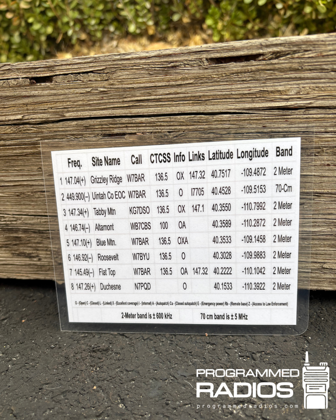
The reverse side lists each repeater in an easy-to-read directory that matches the numbers on the map. Entries include frequency, site name, call sign, CTCSS/PL tone, access info (open/linked/notes), latitude, longitude, and band—making it simple to find the right repeater instantly and pre-program your radios.
These maps are compact, durable, and extremely useful for both beginners and experienced operators. Great for glove boxes, emergency kits, off-roading rigs, and anyone who wants dependable comms without relying on cell service.
Coverage Area Includes:
Utah Counties:
Duchesne County – Duchesne, Roosevelt, Fort Duchesne, Myton, Bridgeland
Uintah County – Vernal, Naples, Jensen, Maeser, Bonanza region
Wasatch County (western edge) – Strawberry Reservoir corridor
Summit County (northern wilderness edge) – Access to the Uinta Mountains, Kings Peak region
Daggett County – Dutch John, Flaming Gorge area
Major Cities & Towns Covered:
Kings Peak / Uinta Wilderness
Dutch John, UT
Flaming Gorge area
Jensen, UT
Bonanza, UT
Fort Duchesne, UT
Roosevelt, UT
Duchesne, UT
Myton, UT
Vernal, UT
Duchesne, UT
Fruitland, UT
Strawberry Reservoir region
Tabiona / Hanna, UT